Friday, May 4, 2012

Hwy 83 5 States, 3 Storms

Entry: April 29th 2012 Chase 2

Well the plan really changed as the dryline setting up in NM fell short into the Midland/Odessa TX area giving us a whole new plan. Today was going to be a casual let's chase anything on the way down to Elk City, OK, to set us up for the following day. A cu field seemed to be blanketing Northeastern CO into Southwestern NE,and as we caught up the clouds began to merge into an area of great moisture convergence. Yuma to Wray Colorado we saw the only cell on radar at the moment trying to punch the cirrus cap and slowly it worked through the pelius layers. We followed this cell that recycled its energy leaving a high base with a curtain of rain.

At this time there was a line of convective storms beginning to bow out near Garden City, KS than finally went severe. Meanwhile we left the cell all by it's lonesome and headed south from Nebraska to Northwestern KS where we saw radar showing a better cell with dbz showing hail markers. This was being spawned from an outflow boundary for the stuff further southern KS. Oakley, KS was a very promising cell for some hail, but we didn't make there in time to see if there was any hail falling. I'm sure a pea or two fell. 

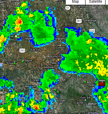
Back to the plan where we originally were going to go, Clovis, NM, there was the tornado warned supercell of the day moving west/east near Lubbock, TX. On Satellite it was as large as a hurricane and all we could do to enjoy it was hope the other cells spawning in TX panhandle would make it's way towards us. The moon was out and lightning strobed in all directions from surrounding storms. We decided to stop south of Canadian, TX to timelapse lightning and a solid looking supercell near Pampa. It had a beautiful hook than weakened as it got to us while sitting on Hwy 83 north of Wheeler, TX. An impressive roll cloud rolled through the skies and we were done. We arrived in Elk City, OK.
Video of Pampa Supercell Rolling!
Storm Reports:
none

Friday, April 27, 2012

Northeastern Colorado LP Supercell April 26th 2012


A day that looked to have dismal hope turned out to be a winner in the chase beginning. Chase 1 was an epic beginning as Northeastern Colorado gave us conditions favorable for a possible organized supercell. Shep and I left approximately around 11:30am and drove to Wiggins, Colorado. My forecast was to aim for Eads, Colorado, but nowcasting I liked the Northeastern Colorado parameters. Even when I was tempted to see what would happen as the beginning of cyclogenesis.  This although would only happen later in the evening in southcentral CO, so I made the decision to hang around the backyard for a possible chance of convection of the front range to hold itself together in the afternoon hours. Shep and I sat around the Ft Morgan/Wiggins area for most the afternoon till 4-5PM when the isolated cell finally made its way into the slight risk line. When I say line, I mean the actual drawn line on the SPC. First it was a long afternoon of waiting and slow progression of weakening and surviving, our stomachs craved substanance (CONEYS FROM SONIC).  We watched the cell begin to beef up as we crammed our food down and headed back up to the now severe warned cell. We were able to find energy again. Both with our hunger for food and a storm, it was now a chase worth mentioning as the severe warned cell started to level out a nice high base. We were able to leisure as this storm all day wasn’t moving fast at all. We could at points of the chase stop to enjoy the mesocyclonic layering structure. Meanwhile it was well relaxed chase and the photos can do all the talking.
Shep was able to do some incredible timelapse and stills of lightning photography while I just watched in amazement. Sitting just west of Sterling we were able to enjoy some nice CG’s out of another impressive meso based storm.
On the way home, an explosive amount of convection began to erupt off the foothills around 9PM. The result of the low pressure enhancing out from the south and a substantial amount of moisture left from earlier convection allowed for a crazy lightning show all around the Front Range. We were driving west towards Greeley on Hwy 14 when Shep and I noticed all the strobe lightning going on just to our south moving quickly due north. We finally got to Hwy 392 which goes southwest towards Greeley and stopped just northeast of Greeley to time-lapse the lightning show moving towards us. The convection was impressive with a defined mesocyclone and low lingering wall cloud. From further investigation of footage, the non-severe cell moving quite rapidly northwards may have produced a funnel, but with night time exposure and flashes of lightning illumination, it is very hard to be convicted of it rotating. With that in mind it is labeled as rotating edge scud for developing wall. The radar and velocity captures both the mesocyclonic feature and outflow very easily.


Make sure to check out the video, FREAKIN SWEET TIMELAPSES!!!

ase 1
Reports: None
 AMAZING VIDEOS FROM CHASE 1:

Day Timelapse Night Timelapse

Thursday, April 19, 2012

Today Timelapsed Some Clouds Rollin Through....

Garden Variety Thunderstorms rolling through the front range. Decided to timelapse and this is what happened.
http://www.youtube.com/watch?v=c5p5jlTFeFU&feature=youtu.be

Also filmed the sunset, wasn't as spectacular I was hoping out to be, but watched a helicopter take off, right around 1:00 into it....watch the outflow produced by the heli...lol.....the rest is history
http://www.youtube.com/watch?v=XeSnN3dk4OM&feature=youtu.be

Thursday, April 12, 2012

Denver's First Spring Severe Thunderstorm of 2012 Season

It goes by saying, wow. Today was an unexpected surprise given I only suspected a hailer and some lightning. If it were to go severe it would be the threat of marginal hail. It was a different type of severe thunderstorm but a typical seasonal spring beginning to the Denver Front Range. As a line of intense storms blew up in the foothills making its way into conditions favorable for an intense blow up scene. My concern was the convection in the south cutting off any warm inflow, but I was wrong. I didn't think it to realize for the past month we had no precipitation and were left with warm pools of air from all the continuous daytime heating from the past month. The southeasterly winds were still pouring in strong against the Palmer into the Denver area providing enough inflow along with the dewpoints closing near the 50's. The Helicity values were perfect for some convergence and some organization of a very strong severe thunderstorm that went tornado warned. Yes. TORNADO WARNED.

The story goes. I went outside from the hospital to get the inflow running on my back and watch the line of storms pushing over the foothills. A linear of nice high based clouds began billowing in from the southwest all the way to DIA. As soon as orographic lifting began to play a role in the embedded chaos of high based thunderstorms. The clouds began rising with strong vertical shear and began converging pretty much right over the hospital. Talk about being in the right place at the right time for once. I just sat there letting the cool rain drops that occasionally fell bring the sensation of spring in my nose. Now the part where it gets interesting is, this sucker has just went severe and I have no idea. I sat there watching the towering cu's busting through the embedded mess, followed with the southern edge of the cell beginning an inflow tail (feeder cloud) than in a dry little bitty slot was incredibly unusual fast horizonal rising motion. The horizontal rising motion along with the cool bitter rain turning warm from an inflow breeze of warm moist air got me all jittery with excitement. It was passing over the hospital and it was hard to see over the building as it was about to do something great!


I ran inside and up the elevator soooo fast. I looked out the near window off the elevator and could see to my east northeastern direction the beginning of a developing funnel cloud. At the this point I started snapping away on my phone. I stood there in amazement and didn't really tell anyone, cause last thing we needed was for everyone to panic. Funny thing is after I watched the whole funneling process for 2 minutes. The hospital finally put out the Tornado Warning drill. Yea they were 10 minutes late for that, hmmm might need to look into that issue here. All in all can't complain.

Wednesday, March 21, 2012

Oklahoma Stacked Low

Oklahoma was cooking up a spew of convective pops within the cyclonic flow all day long today. A few reached a level to spawn a severe thunderstorm warning with the threat of hail and maybe rotation. Some chasers were able to get into position to spot a few funnels in areas of dry air intrusion and merging convection. From 11AM-5PM convection was ongoing bringing chances of funnels and brief touchdowns including hail.

The forecast made from last blog post was a success in terms of the forecast, but location was slightly off. At midnight 06Z SPC put out a see text, therefore it was warranted :) Than midmorning 10AM MST SPC put out a slight risk with a 2% tornado risk in southcentral OK with 15% hail risk.
My target was all shifted to the north as the models showed the stacked low to remain eastward from eastern TX panhandle. If my map for tornado target areas were shifted southwards in latitude than it was a descent forecast. In the reports today on I-Map there were funnels reported but none were reported to have a touchdown. This cold core event was a positive forecast given the ingredients called for low topped supercells which none really had enough shear to allow the supercells to become dangerous.


The satellite was an impressive comma low pressure system which soon fell away as it dissipated or choked itself off from the feeding dry air. Rain showers soon fell away for the state of Oklahoma.

Tuesday, March 20, 2012

Is a See Text Warranted?

A Stacked Low Pressure dominates all levels of our atmosphere bringing a squall of linear precipitation to the Mississippi Valley. In definition a stacked low is helpless with the jet and it's hydrostatic balance. Tomorrow for March 21st the Low Pressure seems to try and sustain itself by redeveloping at the surface. Target for possible embedded early low topped supercells with a slight dry air slot to allow clear for early morning daytime heating exist with very low probabilities. Rotation and turbulent skies should make for an erie day for western OK and up into south west & south central KS.


tornadic proned areas of interest 11AM-3PM
I'm interested to see how tomorrow pans out, given weak dewpoints but enough to create a quick sustaining towering turkey tower to become tornado warned. A lot of factors are weak, but with the help of vorticity and a tight low pressure system, many things could happen. Or it could be a total bust.

Monday, March 19, 2012

Skypecastin' Kansas March 18th 2012


Disregard that I never went out and chased. I rode along side Ryan Shepard through via skype watching his LIVE feed. Technology is amazing and fascinating. Viewing the cu field across the dryline paralleling with hwy 83, it was than Shep would stop in between Garden City and Liberal, KS. Sublette, KS, a town known for the 4 way stop and 4 directions to allow better access to get to storms in case they fired in any direction. While watching and getting all gitty inside over towering turkeys developing, none were simply breaking cap. The only cell from Scott City, KS all the way to the panhandle near Red River curve in TX exploding with supercells of the day was one exploding cell breaking through a touch of blue sky as sun began to slowly go down. All the ingredients for a garden variety thunderstorm blew into the sky. Shep got out and watched it at it's peak before it began to migrate its way north northeast towards Garden City. The moments captured from the LIVE feed aren't measurable as to being there experiencing those moments, even if it is a GVTH(garden variety thunderstorm).

My forecast from yesterday was a little off as far as expectations was concerned. With the divergence of eastern TX panhandle and OK panhandle, I was hoping for a cell to develop and move north northeastward towards east of Liberal. The parameters were subtle for quick tornadic development. The missing ingredient seemed to be a short wave enhancement to help with stronger forcing as the dryline wasn't enough to break the cap. As evening progressed and the cell Shep chased moved off to the north near Dighton, KS, convection from cooling helped some cells to fire up just east of Liberal, KS. I grew excited because my target still looked hopeful especially when the cell turned severe just southwest of Dodge City, KS. My tornado target was a dismal failure. As the timing of the cell to come through this targeted area, in order for a better possible chance for a tornado to develop. Question I will be asking myself is, if Kansas into the northern TX panhandle into OK panhandle were able to break cap earlier than it did, would the conditions be enough for tornadoes to develop in my target area.
Hail was reported just east northeast of Liberal.

015510011 SW MEADE STATE PARKMEADEKS


I'm blown away as to Nebraska and South Dakota sharing in the line of discrete North Northwest and North Northeastward supercells. I was glad to hear that a friend of mine was ok from the reports of North Platte, NE being ambushed with tornadoes at night. Nebraska is seeing their fair share of interesting tornado reports including February. As we continue north on 83, irony, Valentine, NE into SD saw it's own tornadic supercell producing tornadoes as well. 

Watching Elk City surrounded by an amazing explosive nuclear bomb to the south was difficult, not gonna lie. Congrats to all that scored some amazing structure and tornadoes to top it off.