

Disregard that I never went out and chased. I rode along side Ryan Shepard through via skype watching his LIVE feed. Technology is amazing and fascinating. Viewing the cu field across the dryline paralleling with hwy 83, it was than Shep would stop in between Garden City and Liberal, KS. Sublette, KS, a town known for the 4 way stop and 4 directions to allow better access to get to storms in case they fired in any direction. While watching and getting all gitty inside over towering turkeys developing, none were simply breaking cap. The only cell from Scott City, KS all the way to the panhandle near Red River curve in TX exploding with supercells of the day was one exploding cell breaking through a touch of blue sky as sun began to slowly go down. All the ingredients for a garden variety thunderstorm blew into the sky. Shep got out and watched it at it's peak before it began to migrate its way north northeast towards Garden City. The moments captured from the LIVE feed aren't measurable as to being there experiencing those moments, even if it is a GVTH(garden variety thunderstorm).


My forecast from yesterday was a little off as far as expectations was concerned. With the divergence of eastern TX panhandle and OK panhandle, I was hoping for a cell to develop and move north northeastward towards east of Liberal. The parameters were subtle for quick tornadic development. The missing ingredient seemed to be a short wave enhancement to help with stronger forcing as the dryline wasn't enough to break the cap. As evening progressed and the cell Shep chased moved off to the north near Dighton, KS, convection from cooling helped some cells to fire up just east of Liberal, KS. I grew excited because my target still looked hopeful especially when the cell turned severe just southwest of Dodge City, KS. My tornado target was a dismal failure. As the timing of the cell to come through this targeted area, in order for a better possible chance for a tornado to develop. Question I will be asking myself is, if Kansas into the northern TX panhandle into OK panhandle were able to break cap earlier than it did, would the conditions be enough for tornadoes to develop in my target area.

Hail was reported just east northeast of Liberal.
| 0155 | 100 | 11 SW MEADE STATE PARK | MEADE | KS |
I'm blown away as to Nebraska and South Dakota sharing in the line of discrete North Northwest and North Northeastward supercells. I was glad to hear that a friend of mine was ok from the reports of North Platte, NE being ambushed with tornadoes at night. Nebraska is seeing their fair share of interesting tornado reports including February. As we continue north on 83, irony, Valentine, NE into SD saw it's own tornadic supercell producing tornadoes as well.
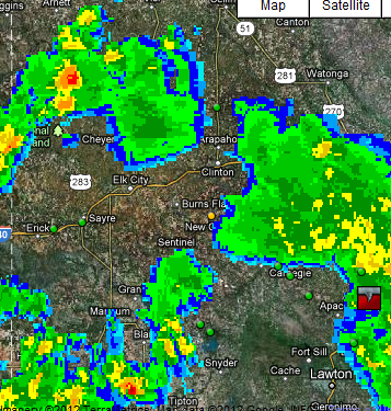
Watching Elk City surrounded by an amazing explosive nuclear bomb to the south was difficult, not gonna lie. Congrats to all that scored some amazing structure and tornadoes to top it off.
 Oklahoma was cooking up a spew of convective pops within the cyclonic flow all day long today. A few reached a level to spawn a severe thunderstorm warning with the threat of hail and maybe rotation. Some chasers were able to get into position to spot a few funnels in areas of dry air intrusion and merging convection. From 11AM-5PM convection was ongoing bringing chances of funnels and brief touchdowns including hail.

 The satellite was an impressive comma low pressure system which soon fell away as it dissipated or choked itself off from the feeding dry air. Rain showers soon fell away for the state of Oklahoma.


