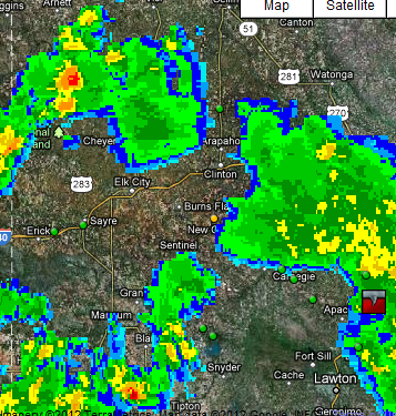
 Oklahoma was cooking up a spew of convective pops within the cyclonic flow all day long today. A few reached a level to spawn a severe thunderstorm warning with the threat of hail and maybe rotation. Some chasers were able to get into position to spot a few funnels in areas of dry air intrusion and merging convection. From 11AM-5PM convection was ongoing bringing chances of funnels and brief touchdowns including hail.
The forecast made from last blog post was a success in terms of the forecast, but location was slightly off. At midnight 06Z SPC put out a see text, therefore it was warranted :) Than midmorning 10AM MST SPC put out a slight risk with a 2% tornado risk in southcentral OK with 15% hail risk.
My target was all shifted to the north as the models showed the stacked low to remain eastward from eastern TX panhandle. If my map for tornado target areas were shifted southwards in latitude than it was a descent forecast. In the reports today on I-Map there were funnels reported but none were reported to have a touchdown. This cold core event was a positive forecast given the ingredients called for low topped supercells which none really had enough shear to allow the supercells to become dangerous.


 The satellite was an impressive comma low pressure system which soon fell away as it dissipated or choked itself off from the feeding dry air. Rain showers soon fell away for the state of Oklahoma.


No comments:
Post a Comment