Friday, June 26, 2009

June 26th Meso Outflow


This was tornado warned in result of again the mountains...Once off the mountains intense shear along with a dominating outflow choked any chance of a structuring mesocyclone, however looking on radar it had the nice green/red reflectivity circle but this was delayed in terms of the tornado sirens going off....later it converged just east of DIA, which once again structured given there was more inflow which evidently resulted as a tornado producer...I could only see dust getting kicked up looking east at the supercell...Outflow is all I can label since the storm was out of my view as far as specifics

Wednesday, June 24, 2009

June 14th


My target area was Kit Carson....we intercepted many cells giving every kind of severe weather related phenomenon you can think of...my favorite was watching the outflow getting kicked up west of Limon....this garden variety thunderstorm was CGing the territory, but kicking up a massive dirt roar in the distance...we let the storm pounce over us and give a treat of hail piling onto Michael Carlson subbie....I stood outside waiting for this sucker....I just love standing out in the moment....
Soon after it passed we diddled around Limon waiting for this line storm to knock it off....I saw a cell that bugged me as we were driving east away from Limon...and all of us together knew we needed to go back....south of Limon was a feast of 2 pair cells..
Driving south 71 we intercepted the front which had a beast of a wrapping around action with rain....I was screaming frantically at Michael "ahhhhhhhhh" full of excitement by that point....I was just eager to meet the southeast quadrant where a supercell was forming with radar evidence...this was cool to watch....than we finally hit a road to drive west a little bit to intercept....in this there were low lingering clouds giving way that this system was just starting...a meso formed to our right as the winds were pushing the side of Michaels car towards the meso wrapping around....hail were getting big....this is when Michael got excited that was funny....than Dann was frantic with excitement looking at the creases on the map....I was doing my thing in the backseat....Skinner world....
anyways we finally got to the east side of the cells merging into this forming mesocyclone layering ontop of each other...
oh another favored moment is trying to hold your camera and stand straight up, yet I lost a lot of weight anyways i think I was on the verge of flying...the inflow towards the meso was the second best inflow i've experienced in a long while...the beavers' tail was developing and looking marvelous...this is when we dropped to the southeast and chased!
We stopped to look back to our northwest and Michael spotted a white funnelish cone popping out of the back near the clearslot engulfed in rain....
it was fairly quick, but we were able to get out and watch this for a few as in front of us the meso was developing a wall slowly as it moved eastward....
Running parallel for a bit with this main storm the wall was giving a cone shape lingering lower to the ground....the boundary is the reason for this whole system coming alive the way it did....when it left the boundary it quickly ceased....only 20 more minutes on the boundary and I believe we would have seen a large tornado on the ground.....all in all a very laid back enjoyable chase
Thanks Michael & Dann
if you want to check out their pics on their blogs (DO IT) lol
http://blog.bigskyconvection.com/2009/06/june-14th-2009-chase-teaser.html
http://michaelcarlsonphoto.blogspot.com/2009/06/photosvideo-tornado-warned-storm-south.html

June 13th

It was a day to relax leaving only for nearby chasing....I headed to intercept a GVTH moving north towards Wiggins....it was a CG rainstorm with the classic look of intensity....than afterwards it was rest time....a severe weather system developed over Fort Morgan over the forecasted period of a threat of tornado possibilities...so funnels were spotted by Shep when he intercepted the cell....
I was in Greeley looking to see the beautiful towering cu's breaking through pelius clouds...pretty gorgeous...I just didn't have the energy so it was good that others were out there...


funnel pics on Shep's blog http://cuttothestormchase.blogspot.com/2009/06/june-13th-2009-funnels1tornado.html

Saturday, June 13, 2009

June 11th


a few of my favorites:

Thursday, June 11, 2009

Colorado Front Range & TX

close to home = fun in CO
TX = fun too with beautiful shortwave......pretty impressive on the tropical jet
tornado outbreak in TX

June 9th Kansas


Sitting on a county road north of Coldwater, KS we were waiting for initiation....on radar was development off the warm front moving NE into Dodge City...I was waiting for the low to retrograde so storms would collide with the boundary....it was roughly an hour after we left this spot to catch the cell moving NE out of OK moving east of Witchita...this is why you never leave your target area....a supercell developed from the initiated cells off the warm front and collided with the boundary moving them SE towards our direction into Greensburg.....a tornado produced 4 miles WNW of Greensburg making the total distance 50 so miles from my original tornado point in Isabel....the storm was progressing in the direction of Isabel but fizzled out....


This was the left moving cell that split off from the main cell in OK

Left moving circulation was a first for me....there was beautiful rotation but not enough to withstand what was soon to be an outflow washout....quarter sized hail fell, but at that point I was disappointed....finding out of missing the supercell of the day....and stuff back in my hometown Greeley.....yes I knew this was going to happen and I took the risk because I believed in my forecast...just didn't follow through.....
The rising towers were fun to watch as there was amazing buoyancy and explosiveness as it moved into high level of CAPE

Tuesday, June 9, 2009

Chasers Convergence Today

Heading to Kansas today....CAPE playing really well close to Coldwater, KS as far as initiation goes....with easterly northeast component the storms will move eastward
Isabel would be my tornado target
See ya'll out there

Monday, June 8, 2009

June 7th Teaser No Tornadoes Seen


if you want to see tornadoes in & near Denver
http://blog.bigskyconvection.com/ by: Dann Cianca
http://stormchaserco.blogspot.com/ by: Eric Carlson

Sunday, June 7, 2009

Supercell near Mullen, NE

pics from yesterday....


Here is the outlook for today to start off.......


Yesterday we sat in Lexington with only an option of Iowa or the cells that began popping up in west NE....we acted fairly quick on the decision by leaving after the cells in order that we would be chasing on the way home given conditions of other severe weather wouldn't happen till later that night moving through KS into Iowa....
Shep & I along with Becca & Dave got there when the storm was still structured than the meso sheared out....this went through another process as it did recollect and developed another meso as it moved east....
We decided naturally to let the outflow pound us with some hail....quarter sized hail began dumping....this was my chance to experience the true outdoors....I went outside and Shep watched than joined me as he knew I was having way too much fun.....
All in all it was a fun chase given it could have been a total bust....lightning was later seen that night with late night convection in NE Colorado into Wyoming......
Today we have a slight risk extending all the way into NE CO....I won't be heading out to the MOD risk that is setting up in KS....
We are out of energy, sleep & rest.....we can't stay in hotels since it cost too much and production team had to return.....the last couple of days have been amazing....missing the WY tornado was unfortunate but I have to continue to hope and believe in my forecast....I will be analyzing that day as to what was missing and such....

Saturday, June 6, 2009

Waiting for initiation in Lexington, NE


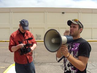
Don't give Shep a megaphone, it becomes CHAOS! in North Platte.....

Shep & I regrouped with Becca & her friend Dave.....now we wait for anything to pop

Friday, June 5, 2009

Chasing west to east, CAPE!!!!!!!! Supercell Nebraska

This was our leftovers on the Wyoming Supercell that continued into Nebraska....this storm was impressive to say the least as far as structure of mesos and wall cloud formation....it looked to want to drop a tornado at any time but didn't have enough vorticity to get it spinning vertically....Every chaser in America witnessed this massive supercellular system.....


I will be near Greeley, CO waiting for initiation and possible tornado NE of town.....till than see the world of chasers out there.....

This is beautiful Tornado SPC

June 4th Cheyenne Ridge


A classic front range setup....it was nice to grab a Dew and watch the towering cumulonimbus clouds explode off both the Palmer and Cheyenne Ridges....I went after the Cheyenne Ridge....Shep & I with another production team went to wait near Ault....when the CIN capped everything from the first shower rain storm....we were left with what was in between us....
Sitting there waiting for a half hour with a friend Chris Yates currently from Cheyenne...we decided best better leave, to intercept the cell moving southeast just east of Cheyenne. We intercepted and tried to punch the hail core but the road network was awful because they were all dirt roads and they were soaked from all the hail and rain that dumped....so we let it pass after we realized we couldn't get in position to get some hail....another cell that in fact Chris left to go back to Cheyenne to intercept was now making its way over towards us
This is when Shep & I did an incredible timelapse shot....for the Cut To The Chase production which were hoping will come together nicely.....
Stay tuned tomorrow... Till than with the risk better for isolated supercells, we are excited....should be good times

Thursday, June 4, 2009

SPC Greeley


Greeleyuia Greeleyuia, Greeluia, oh ah Greeeeeeeleeeeeeeeeuiiiaaaaaaaaaaaaa!!!
Nuff said

Wednesday, June 3, 2009

EARLY START SUPERCELL?


LOOKING AT ALL THE MODELS SHOW POSSIBLE INITIATION AROUND 12-1PM! I WILL BE COOKING HOTDOGS FOR AN EARLIER LUNCH THAN EXPECTED THAN GOING OUT TO TIME LAPSE THIS EXPLOSION HOPEFULLY! WILL SEE WHAT HAPPENS.....

June 2nd


What a day...being up for the last 40 hours or so....with driving to the target area in north central TX, chasing, than driving all the way back through the night to Greeley.....
The cells we chased near Abilene, TX were tornado warned cells...this was a beautiful green grotesque hail looking meso shelf cloud all in a great combo! We didn't arrive early enough to see the big hail or get up close to the developing foot wall cloud...we did however see the wall cloud from a far distance on the south side of the southeastern moving cell moving towards Abilene....beautiful shear as the storm produced an intense outflow...this creating massive wind gust and lots lots lots of rain! good stuff!
Later I will post a drive back severe thunderstorm that we encountered near Guthrie, TX in the middle of the night! This was producing probably the second best lightning storm in my chasing book! Incredible CGs, almost unbelievable.....so soon as I cut up the footage stills.....

Multi Convective Cells converge to MCS


June 1st
My forecast has been focused on this area because if conditions would have shifted at all in order for the ingredients of a supercell to develop; we would have been the only committed down there. It was a "See Text" SPC outlook for awhile till we were heading south in Kansas; SPC put out a slight risk on the target....this was what I was happy about despite the fact it didn't come together.....
Shep & I along with the production crew veered south to Texas towards the town of Pampa....lack of moisture and upper level winds at the right time were not allowing the cells to gain strength before the cells were looking to each other for help to stay alive therefore creating a massive MCS for northern TX by sunset...
They were beautiful high based cells for sure....